The orbit is getting busier and crowded quickly. SpaceX recently announced their space monitoring system, Stargaze, to monitor the orbital real estate. From LEO satellites providing global connectivity to ambitious moonshot projects like Google’s Suncatcher—which aims to scale AI infrastructure in LEO by capturing the unlimited supply of solar energy needed for massive AI compute, Low Earth Orbit is becoming a critical real estate zone in the space. With the launch costs projected to decrease to less than $200/kg by the mid-2030s, we are on the verge of seeing a massive influx of constellations serving a variety of purposes.
What is SSA?
Space Situational Awareness (SSA) is the comprehensive knowledge and characterization of space objects and their operational environment. Think of it as a global Air Traffic Control (ATC) for space. It involves tracking satellites, debris, and natural space weather to predict potential collisions (conjunctions) and ensure that space remains a sustainable place for technology to operate.
What are the different ways the object in space is tracked today?
The different ways include the below –
Ground based radars – This work by emitting radio waves to bounce off objects and calculate their distance and speed.
Optical telescopes – These track objects by capturing reflected sunlight, which is especially effective for satellites in higher orbits.
Space based sensors – Satellites equipped with cameras (like star trackers) can now look sideways or outward to spot other objects from within the orbital environment itself.
Utilizing the above, powerful algorithms take these observations and turn them into orbital predictions, telling operators exactly where an object will be days in advance.
Does the existing system cover all space objects?
Not yet. While we are getting better, the existing systems are limited by the object’s size. We can reliably track objects larger than a softball (roughly 10cm) in LEO, but millions of smaller pieces of debris – like paint flecks or small bolts are still flying around blindly. If it’s too small to reflect enough light or radar energy, it stays off the grid.
What is the space traffic management system from SpaceX?
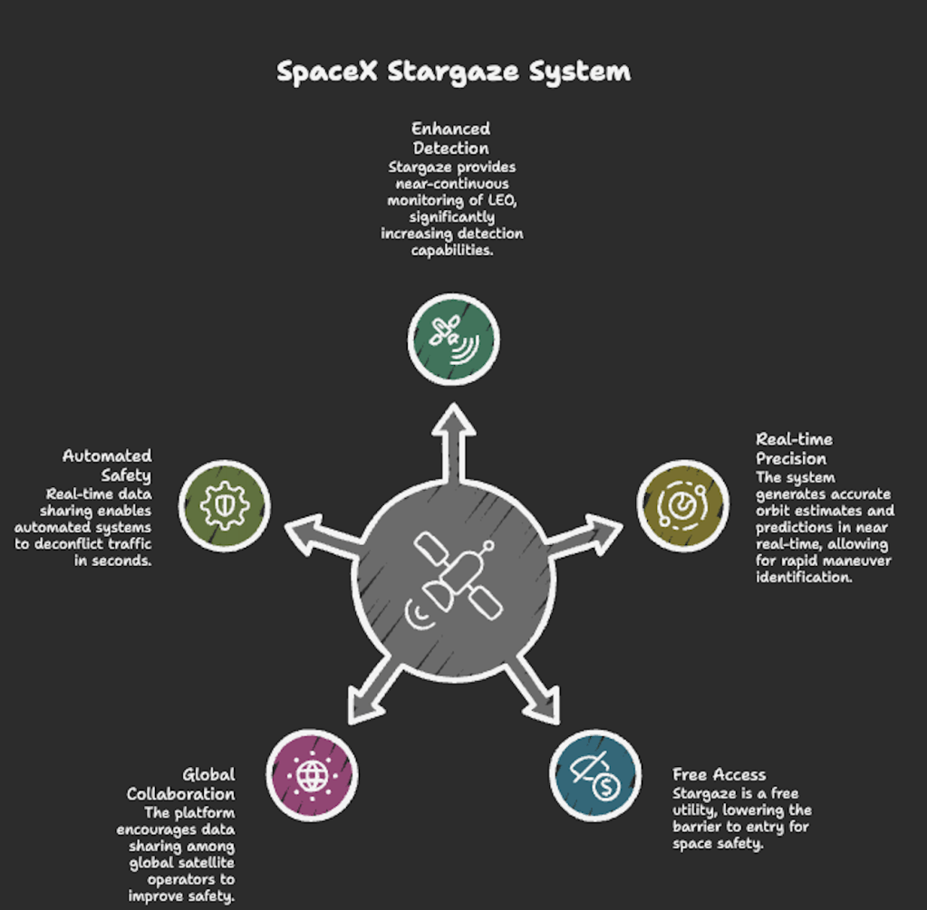
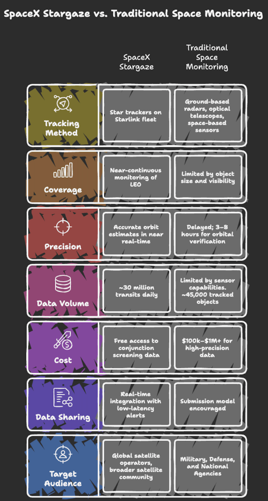
SpaceX recently launched a system called Stargaze. Unlike traditional ground-based systems, Stargaze utilizes the nearly 30,000 star trackers already installed on the Starlink fleet. These trackers detect other orbiting objects in real-time, providing millions of transits or sightings daily. SpaceX has integrated this into a free-to-use space-traffic management platform that shares Conjunction Data Messages (CDMs) with other operators to improve global safety.
How much coverage does Stargaze provide?
It represents a several order of magnitude increase in detection capability compared to traditional ground based systems. While standard radar and optical telescopes might only see an object a few times a day, Stargaze provides near-continuous monitoring of the LEO environment.
Precision – By aggregating these millions of sightings, Stargaze generates accurate orbit estimates and predictions for position and velocity in near real-time. This allows the system to identify maneuvers (changes in a satellite’s path) within minutes, whereas the current industry standard often takes several hours to confirm a change in trajectory.
The Hardware – It leverages nearly 30,000 star trackers already active on the Starlink fleet.
The data volume – These sensors detect approximately 30 million transits (sightings) of orbital objects every single day.
Who can use Stargaze?
Safety in space is a collective responsibility, so SpaceX has made Stargaze a free utility.
Cost – Access to Stargaze conjunction screening data is provided free of charge. The goal is to lower the barrier to entry for space safety, ensuring that even operators with limited budgets have the data they need to avoid collisions.
Global satellite operators – Any operator—whether commercial, civil, or government—can use the platform.
The community – It is open to the broader satellite community, from large constellations like OneWeb to smaller academic CubeSat missions.
How is the data being used? (Data sharing and access)
SpaceX provides access to this data through its dedicated platform. The system is built on a give and get philosophy to maximize safety.
Real-time integration – Once integrated, operators receive low-latency alerts based on Stargaze’s high-frequency observations combined with the ‘truth’ data provided by other participants. This creates a unified live map of LEO that is updated far more frequently than public government catalogs.
The beta and beyond – After a successful ‘closed beta’ with over a dozen major operators, the platform is now opening up to the wider industry.
How to get the data – Operators gain access by using SpaceX’s APIs. See below for a listing of the most recent set of ephemeris predictions:
https://api.starlink.com/public-files/ephemerides/MANIFEST.txt
This data is also uploaded to space-track.org.
The submission model – To receive Conjunction Data Messages (CDMs)—the specific alerts that tell you if you are on a collision course, the operators are encouraged to submit their own ephemeris data (their predicted flight paths) to the platform.
Why is it important for all satellite operators to share ephemeris data in real time?
Ephemeris data is a satellite’s specific flight plan or predicted trajectory. Sharing this in real time is critical because of the following reasons.
Automated safety – As orbits get more crowded, we don’t have time for phone calls between engineers. Real-time data sharing allows automated systems to deconflict traffic in seconds rather than hours.
Maneuver awareness – If operator A moves their satellite without telling operator B, they might accidentally move into a new collision path.
Reducing uncertainty – Sensors can guess where a satellite is, but the operator knows where it is. Sharing the truth data makes every prediction more accurate.
I would like to hear more about your learning on the space monitoring systems.
Happy learning!
